For the Love of Maps
Once in a while, when I'm sorting through my old posts, I find one that I want to tweak or play with a bit. This is one of those, and now I'm posting it again. Why do all that editing work, and not post?
Then, when I was 7 and my sister was 5, I convinced her to accompany me clear across Wheaton to visit some friends of ours. I didn't ask first, because I knew the answer would be "no". So we wouldn't be discovered and our trip cut short, I took a back way I had memorized from the city map. I can't remember for sure whether we actually reached our friends' house or not, but I do remember walking for a very long time. I knew exactly where I was, so I wasn't worried. For my parents, I'm sure, it was a different story. The odd thing, though, is that I don't remember getting into any trouble over this. I guess my parents were so relieved to have found us that thoughts of punishment were forgotten.
I've never stopped loving maps. I think in maps, and when I think of people, I think of them in their place on the map I have in my head. That's how I catagorize people, I guess, even people who live two blocks over from me. If someone lives halfway round the world, then I think of them in their area of the globe. If I don't know someone's place, then I can't put them in that concrete spot that makes them not just a disembodied spirit, but real person.
 Here's a map of my place. It's a too small to see well, but you can always click on it for the larger view. Somewhere in that little black dot labled Whitehorse is my house.
The highlighted yellow line is the Yukon River, which brings me to another reason that maps are so much fun: They tell you all kinds of interesting things. You'll notice that all the run-off from around my house (and I have lots of it this year!) goes into the Yukon River, and then up and out to the west coast of Alaska into the Bering Sea. I'm only a hundred miles from the coast, but the mountains in between make the long way--1300 miles or so across Alaska to the Bering Sea--the easy way out for the water in my ditch.
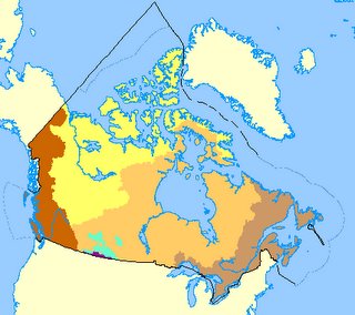 And while we're on the subject of water drainage and maps, here's a little map of the fresh water drainage of all of Canada. The yellow and gold portions, which together make up 75% of Canadian land, drain north into the Arctic Ocean or Hudson Bay. The two brownish sections on either side drain into the Pacific and Atlantic Oceans. (See how the majority of Yukon water drains into the Pacific Ocean, and only a small section goes north to the Artic Ocean?) The tiny purple area on the border of Saskatchewan, Alberta and the U.S. drains out the Missouri River, into the Mississippi, and down to the Gulf of Mexico.
That land locked aqua section? Officially, that section has what's called internal drainage, but I prefer to think of it as draining into rivers that go nowhere. It sounds so much more mysterious that way.
Or we can have fun with maps by matching them with photos. Here's a map of the glaciers and icefields of Canada. Here's a photo of one of those glaciers and/or icefields (one of the ones up on the B.C./Yukon border) taken by oldest son.
There is at least one person who loves maps more than I do. He has a whole blog devoted to them. It's called The Map Room, and you'll find all the latest maps and map news there.
As long as you've come this far, why don't you leave a comment and give me a general idea of your place, so I can pinpoint you on the map in my mind? No specifics necessary; a state or country is enough. The last time I did this, some smart alecks gave me their GPS coordinates. That does nothing for me. I don't have a GPS system in my mind--just a map. So, if you must give your GPS coordinates, please give a place name as well, and I'll be happier.
Tags: maps, place
I started loving maps when I was quite young. I can remember poring over gas station road maps before I started school. I liked those phone book city maps, too, and often spent hours studying them so I could understand where everything was. I wanted to know how to go to the places I wanted go.
...I took a back way I had memorized from the city map...
Generally speaking, I was an obedient child--the sort a parent could trust to be doing what was expected. There were a couple of times, however, when my map reading obsession fueled my quest for adventure, and I went places I wasn't supposed to go. Once, while walking home from kindergarten, I decided to try walking round that enticing circle of road that rings the central buildings on the Wheaton College campus rather than cutting straight through the campus like I had been taught. Of course, that took quite a bit longer, and when I didn't arrive home from school on time, my worried parents took the car out searching for me. There I was, my mother says, completely unconcerned, walking the long way home as if I knew what I was doing. And I did know what I was doing.Then, when I was 7 and my sister was 5, I convinced her to accompany me clear across Wheaton to visit some friends of ours. I didn't ask first, because I knew the answer would be "no". So we wouldn't be discovered and our trip cut short, I took a back way I had memorized from the city map. I can't remember for sure whether we actually reached our friends' house or not, but I do remember walking for a very long time. I knew exactly where I was, so I wasn't worried. For my parents, I'm sure, it was a different story. The odd thing, though, is that I don't remember getting into any trouble over this. I guess my parents were so relieved to have found us that thoughts of punishment were forgotten.
....I think of them in their place on the map I have in my head...
All that practice made me an accomplished map reader, so that by the time I was in first grade, I was helping my mom navigate the city by running into phone booths to check the maps for directions whenever we got lost. When I started reading books, the books I loved most were books with a map for tracing the story--maps of the Hundred Acre Wood, or Archenland, or Middle Earth. If a book didn't have a map, I would sometimes draw one that worked. I drew my own imaginary maps, too, of my own imaginary cities and countries and national parks.I've never stopped loving maps. I think in maps, and when I think of people, I think of them in their place on the map I have in my head. That's how I catagorize people, I guess, even people who live two blocks over from me. If someone lives halfway round the world, then I think of them in their area of the globe. If I don't know someone's place, then I can't put them in that concrete spot that makes them not just a disembodied spirit, but real person.
 Here's a map of my place. It's a too small to see well, but you can always click on it for the larger view. Somewhere in that little black dot labled Whitehorse is my house.
The highlighted yellow line is the Yukon River, which brings me to another reason that maps are so much fun: They tell you all kinds of interesting things. You'll notice that all the run-off from around my house (and I have lots of it this year!) goes into the Yukon River, and then up and out to the west coast of Alaska into the Bering Sea. I'm only a hundred miles from the coast, but the mountains in between make the long way--1300 miles or so across Alaska to the Bering Sea--the easy way out for the water in my ditch.
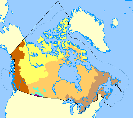 And while we're on the subject of water drainage and maps, here's a little map of the fresh water drainage of all of Canada. The yellow and gold portions, which together make up 75% of Canadian land, drain north into the Arctic Ocean or Hudson Bay. The two brownish sections on either side drain into the Pacific and Atlantic Oceans. (See how the majority of Yukon water drains into the Pacific Ocean, and only a small section goes north to the Artic Ocean?) The tiny purple area on the border of Saskatchewan, Alberta and the U.S. drains out the Missouri River, into the Mississippi, and down to the Gulf of Mexico.
That land locked aqua section? Officially, that section has what's called internal drainage, but I prefer to think of it as draining into rivers that go nowhere. It sounds so much more mysterious that way.
Or we can have fun with maps by matching them with photos. Here's a map of the glaciers and icefields of Canada. Here's a photo of one of those glaciers and/or icefields (one of the ones up on the B.C./Yukon border) taken by oldest son.
There is at least one person who loves maps more than I do. He has a whole blog devoted to them. It's called The Map Room, and you'll find all the latest maps and map news there.
As long as you've come this far, why don't you leave a comment and give me a general idea of your place, so I can pinpoint you on the map in my mind? No specifics necessary; a state or country is enough. The last time I did this, some smart alecks gave me their GPS coordinates. That does nothing for me. I don't have a GPS system in my mind--just a map. So, if you must give your GPS coordinates, please give a place name as well, and I'll be happier.
Tags: maps, place
posted by Rebecca Stark at 4/25/2006 12:55:00 AM
![]()
![]()


<< Home